
Provide feedback on this item
Please provide details, labels, or ideas that will help this image be more findable and better described.

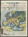
Guide to the next war in Europe
This map shows railways throughout parts of Eurasia and Africa; naval bases controlled by Great Britain, France, Italy, Germany, Greece, and Yugoslavia; charts comparing the number of capital ships, aircraft carriers, heavy cruisers, light cruisers, destroyers, and submarines controlled by the British Empire, France, Germany, and Italy; a chart comparing air forces of the British Empire, France, Germany, Italy, and Russia; and a chart comparing military strength according to regular armies and trained reserves of Russia, France, Italy, Germany, Spain, the British Empire, and other European countries. The map was drawn in 1937, two years before the beginning of World War II. The map is signed by W. H.Wisner.
1937-08-08
49 x 37 cm
Tribune Company
color
- English
- Military organizations--Allied Forces--1930-1940
- Military organizations--Axis--1930-1940
- Naval yards & naval stations--Allied Forces--Europe--1930-1940
- Naval yards & naval stations--Axis--Europe--1930-1940
- still image
- text
- These materials are either in the public domain, according to U.S. copyright law, or permission has been obtained from rights owners. The digital version and supplementary materials are available for all educational uses worldwide.
- The Janet A. Ginsburg Chicago Tribune Image Collection
- Chicago Sunday Tribune (August 8, 1937), Graphic Section, p. 1
- application/pdf
- image/jpeg

- Home
- About
- Full Text Search
- Browse
- Contact Info