Dating Clason State Road Maps
Overview (1923 - 1931)
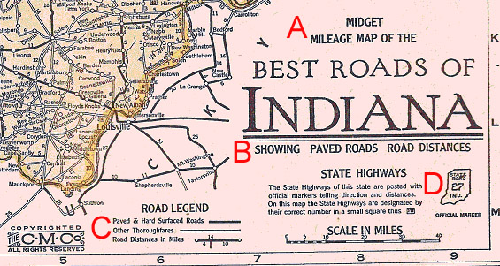
The Clason State Map Dating Guide, is organized by state and lists the map features such as the title, sub-title, road legends, and official highway markers year by year. One should use these features on the state map to delineate the year. In the Indiana map below, for example, the title (A) is “Midget Mileage Map”, the sub-title (B) is “Showing – Paved Roads – Road Distances” the Road Legend (C) lists “Paved and Hard Surfaced” and “Other Thoroughfares,” and the official highway marker (D) is “Route 27.” A perusal of the Guide indicates that an Indiana map with these characteristics would be dated as 1924 (1924a was an early variant and 1924b, if listed, was a later variant, possibly early 1925; there was also a later variant of 1926, labeled 1926c). Midget maps, which were typically identical to the regular maps except in size, were produced in several years along with the regular maps.
The Clason maps became more standardized in 1928, so after that date there were fewer variations in the map features by state and year. If there are no changes in the map features for a particular year, this will be indicated in the second column of the guide (e.g. same as 1928). A more precise dating of these later maps can only be obtained by a careful scrutiny of the yearly changes in the road networks of these particular states. In Michigan, for example, the route from St. Johns to Owosso was just an all weather road on the 1928 map, but became a paved road on the map of 1929; on the 1930 map, U.S. 27 north of St. Johns was paved only to Mt. Pleasant, but on that of 1931 paving extended to Clare. Similar information relating to the other state maps during this period will hopefully be generated in the not too distant future. Finally, it is important to recognize that the guide is based on the maps contained in the Clason Touring Atlases. Consequently, there are likely to be versions of the state maps that do not appear in the Touring Atlases and thus that are not listed in this Guide. The Guide should be viewed as preliminary and as a work in progress, so any missing versions, corrections, or comments are most welcome.
“Typical” Road Legends By Year
| Year | Road Legend | Key |
|---|---|---|
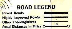
| 1923 |
|
"Highly Improved Roads" |
| 1924 | 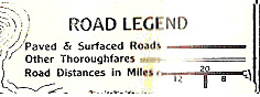 |
"Paved and [Hard] Surfaced Roads" or, if you see only two road classifications |
| 1925 | 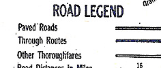 |
"Through Routes" or "Best Roads" |
| 1926 | 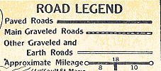 |
Graveled Roads (or any mention of gravel), plus no roads printed in red |
| 1927 | 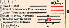 |
Red roads (Red U.S. Highways appear for the first time and in all subsequent years) along with a mention of gravel and/or macadam roads |
| 1928 | 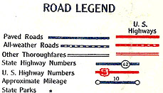 |
All-Weather Roads, plus (Blue) printing |
| 1929 - 1931 | 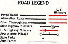 |
All-Weather Roads, plus (Black) printing |